


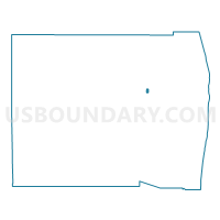
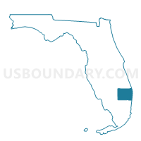
6082-Voting District, Palm Beach County, Florida
About
Outline

Summary
| Unique Area Identifier | 557697 |
| Name | 6082-Voting District |
| County | Palm Beach County |
| State | Florida |
| Area (square miles) | 0.51 |
| Land Area (square miles) | 0.38 |
| Water Area (square miles) | 0.13 |
| % of Land Area | 74.90 |
| % of Water Area | 25.10 |
| Latitude of the Internal Point | 26.72850010 |
| Longtitude of the Internal Point | -80.26030260 |
Maps

Graphs
Select a template below for downloading or customizing gragh for 6082-Voting District, Palm Beach County, Florida


Neighbors
Neighoring Voting District (by Name) Neighboring Voting District on the Map
- 6072-Voting District, Palm Beach County, FL
- 6080-Voting District, Palm Beach County, FL
- 6084-Voting District, Palm Beach County, FL
Top 10 Neighboring County Subdivision (by Population) Neighboring County Subdivision on the Map
Top 10 Neighboring Place (by Population) Neighboring Place on the Map
- The Acreage CDP, FL (38,704)
- Royal Palm Beach village, FL (34,140)
- Loxahatchee Groves town, FL (3,180)